Places & landmarks
Pico Viejo: Teide's Overlooked Twin and Its 800 m Crater
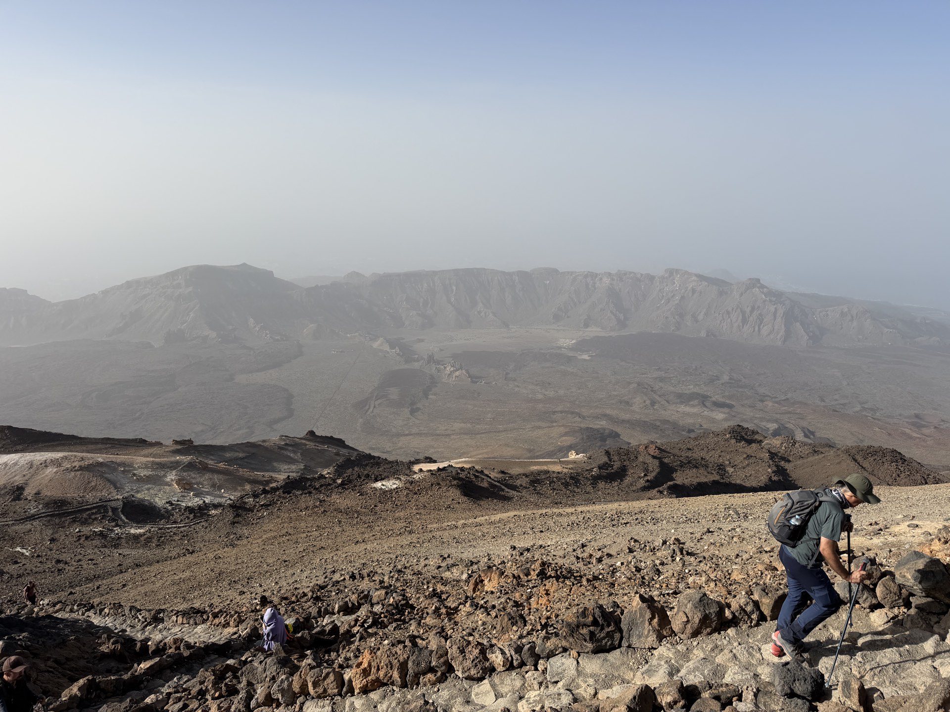
The true scale of the Teide–Pico Viejo complex only makes sense when you look away from the highest point. Shift your gaze south-west from Teide’s cone and a broader, darker shape fills the frame. That is Pico Viejo — or Montaña Chahorra — the island’s second summit at 3,135 m and the owner of a crater so disproportionately large it rewrites what you thought a volcanic vent should look like. Standing at the viewpoint on its rim, you are not gazing down into a neat bowl but into a chasm roughly 800 m across, an amphitheatre of altered rock whose colour banding tells a longer and more violent story than Teide’s comparatively tidy summit ever could.
The peak receives a fraction of the foot traffic that crowds its taller neighbour, partly because it is slightly lower and partly because the cable car narrative centres so completely on Teide’s cone. Yet the walk from La Rambleta to the Pico Viejo viewpoint — Trail 11 — demands no summit permit and delivers one of the most geologically explicit panoramas in the national park. This is not a consolation prize for those who failed to secure a Telesforo Bravo slot. It is a destination worth planning a day around.
A second summit that shaped the skyline
Pico Viejo is not a satellite cone. It forms the south-western limb of the same central volcanic edifice as Teide, a twin-strung structure built by overlapping cycles of eruption and collapse. The two peaks share a base, a plumbing system and a geological history, but their surface expressions could hardly be more different.
Where Teide rises to a neat, pale summit cone that photographs cleanly against almost any sky, Pico Viejo presents a broader profile. Its flanks are darker, scarred by relatively recent lava flows from the 1798 eruption, and its summit crater is not a single throat but a wide depression whose rim undulates in a series of minor highs and lows. The crater is the thing. At roughly 800 m in diameter, it dwarfs Teide’s summit crater — a feature measuring about 80 m across — by an order of magnitude. When you stand at the La Rambleta upper station at 3,555 m and look down into Teide’s summit pit, you see a vent. When you walk Trail 11 to the Pico Viejo viewpoint and look across its crater, you see a landscape.
The altitudinal difference between the two summits is only 580 m, but the experiential gap is wider. Teide’s summit feels like a hard-won apex, a point from which the island falls away in every direction. Pico Viejo’s rim feels like the edge of something that is still in progress, a wound that has not healed because in geological terms it barely closed.
The crater that outdoes its neighbour
The 800 m crater is the centrepiece of any visit and it rewards slow looking. Its walls are not monotone. Hydrothermal fluids circulating after the crater’s formation have altered the original basalt and scoria, painting the interior in yellows, ochres, rust-reds and grey-greens. These colours are not decorative. They are a chemical record of steam, acid gases and heated water working through fractured rock, oxidising iron and depositing sulphur compounds over centuries.
From the viewpoint, the far wall of the crater rises in a sequence of layered tuffs and lava benches, some near-vertical, others sloping in unstable scree fans. The floor is uneven, punctuated by small secondary vents and collapse features, and in the right light you can make out the traces of old lava lakes that once pooled and drained here. The scale is what stays with you. You could drop Teide’s entire summit cone into this crater and still have room around the edges.
Teide’s summit crater is the tight, functional throat of a stratovolcano — dramatic in its own right, but limited by its dimensions. Pico Viejo’s crater is a caldera-like bowl on a summit, a feature more often associated with entire volcanic massifs than with a single peak. It belongs to the same family as the larger Las Cañadas caldera, a reminder that collapse is as fundamental to this landscape as construction.
Montaña Chahorra and the confusion of names
The peak is known by two names and they are not fully interchangeable. Pico Viejo — Old Peak — is the Spanish label that appears on modern maps and trail signage. Montaña Chahorra is the older toponym, still used locally and often conflated with the eruption vents on the peak’s western flank.
The dual naming is typical of Tenerife’s volcanic geography, where indigenous Guanche names, colonial Spanish descriptors and later scientific designations have layered over each other. Chahorra likely predates Pico Viejo, though its precise meaning is not firmly established. What matters for the visitor is that both names point to the same mountain, and that the 1798 eruption is formally called the Narices del Teide or Chahorra eruption — tying the peak to the most significant volcanic event of the modern era on Tenerife.
The 1798 eruption: Narices del Teide
Between June and September 1798, a fissure opened on Pico Viejo’s western flank and stayed active for roughly three months. It was the longest historical eruption recorded on Tenerife, and it came not from the summit crater but from lateral vents lower down the mountainside.
| Feature | Detail |
|---|---|
| Name | Narices del Teide (Teide’s Nostrils), also Chahorra eruption |
| Dates | June – September 1798 |
| Duration | Approximately 3 months |
| Vents | Flank fissure on Pico Viejo, not summit crater |
| Lava type | Aa and blocky basaltic flows |
| Notable outcome | Longest historical eruption on Tenerife |
The lava that emerged was dark, basaltic and fluid enough to travel significant distances, though it did not reach populated areas. Today, the flows remain strikingly bare. Nearly two and a quarter centuries of weathering have done almost nothing to soften their surface. Walking across the malpaís — badland — of the 1798 flow, you see twisted ropes of cooled lava, pressure ridges and collapsed blisters, the whole surface a glossy black where the desert varnish has not yet dulled it. Lichen has barely got a foothold. It looks as though it cooled last year.
The Narices vents themselves are visible from the western approach roads and from higher points on the TF-38. They are not marked by a substantial cone — the eruption was fissure-fed and the vents appear as a line of spatter ramparts and small craters along the flank. Their modesty at ground level belies the volume of material they produced. The eruption was well documented by contemporary observers, including scientists and officials in Puerto de la Cruz, and its lava fields remain one of the best-preserved historical volcanic landscapes in the Canary Islands.
The view from the rim
The Pico Viejo viewpoint at the end of Trail 11 is not signed as a major attraction. It is a widening in the path with a low stone wall, set back slightly from the crater edge for safety. The effect is immediate. One moment you are walking across a high-altitude plain of pale pumice gravel, the retama bushes thinning out as you climb; the next, the ground drops away into a void of colour.
Looking across and down, the crater walls present layered histories. The lower sections are older, darker basalts, cut by dykes that stand out as vertical ribs. Above them sit the altered tuffs, banded in yellows and reds from fumarolic activity. The rim itself is a jumble of scoria and welded spatter, oxidised to a rusty crust. On clear days you can see the island of La Gomera floating on the Atlantic to the west, and the curve of Tenerife’s south coast below.
To the north-east, Teide’s cone dominates, its pale flank rising above the Llano de Ucanca. From Pico Viejo’s rim the relationship between the two peaks becomes spatial in a way that no map conveys. You can trace the ridge that connects them, see how the lavas of one overlap the other, and understand why geologists treat them as a single structure.
The viewpoint also offers a glimpse of the 1798 lava flows, snaking away from the western flank in a black fan. From this height, the flow field’s boundaries are crisp, its contrast with the surrounding older terrain absolute.
Trail 11: access without a permit
One of Pico Viejo’s quiet advantages is that its main overlook is accessible without the high-demand summit permit required for Trail 10 to Teide’s peak. Trail 11 branches off from La Rambleta, the upper station of the cable car at 3,555 m, and follows a well-defined path across the high ground. The route is not technically difficult, though it is entirely at altitude and exposed to sun and wind.
Because it does not lead to Teide’s absolute summit, Trail 11 is consistently quieter. On days when the cable car is ferrying hundreds of visitors to La Rambleta and the 10:00 am summit-permit slots are long gone, the Pico Viejo path sees a fraction of that traffic. You will share the viewpoint with a handful of walkers at most, often with no one. The quiet is disproportionate to the scale of the landscape.
The path itself is worth noting. It crosses the upper flanks of the complex through a zone where the vegetation is minimal — a few Teide violets in season, retama shrubs bent by the prevailing wind, and the pale pumice gravel that makes the high Teide country look deceptively like a winter scene. The surface is loose in places but generally firm, and the gradient is moderate. This is not a scramble. It is a steady high walk with an extraordinary payoff.
Why it stays quieter
Fame is an unevenly distributed resource on Teide. The summit, the cable car, the Roques de García, the observatory, the stargazing tours — all cluster around the same well-publicised circuit. Pico Viejo sits outside that loop, partly because it is not the highest and partly because the trail from La Rambleta is a there-and-back spur rather than part of a scenic circuit. Most visitors arriving by cable car walk the short signed paths around La Rambleta, look at Teide’s summit cone and descend. Trail 11 requires a decision.
That decision is almost always the right one. The extra walking time is small in the context of a full day in the park, and the reward is a crater view that outstrips anything visible from the standard viewpoints. For hikers walking up from the Montaña Blanca trailhead rather than taking the cable car, the Pico Viejo spur adds time and altitude gain, but the logic still holds — the detour delivers a quieter, more expansive perspective than the main summit track.
The absence of a summit permit barrier is also part of the psychology. People who have planned a Teide ascent months in advance and secured a slot on Trail 10 will naturally prioritise that goal. Those without a permit often assume that the high ground is closed to them. Trail 11 proves otherwise. It is one of the few places in the national park where you can stand on a major summit without paperwork, and that alone makes it worth knowing.
Photography and light
Pico Viejo’s crater photographs best in late-afternoon light, when the sun strikes the western interior wall and brings out the full range of ochres and reds. Morning light on the crater can be flat, with the eastern rim casting shadow across much of the visible interior. Overcast days mute the colour banding but add drama to the scale — the crater becomes a grey amphitheatre, and the absence of colour sharpens the eye for texture and shadow.
The peak itself is most striking from a distance. From the Mirador de Chío or the TF-38 as it climbs through the pine belt, Pico Viejo’s dark profile against the sky makes a stronger silhouette than Teide’s more symmetrical cone. At dawn, the first light catches Pico Viejo before it reaches the caldera floor, painting the crater rim in warm tones while the plain below remains in shadow. Photographers working the classic Teide viewpoints often overlook this; the mountain itself becomes a foreground object rather than the subject, but a long lens and a clear morning can produce images that show the crater’s scale in relation to the surrounding terrain.
The colour palette of altered rock
The yellows, ochres and reds of Pico Viejo’s crater interior are the product of hydrothermal alteration — a process in which acidic fluids, heated by residual magma at depth, rise through fractures and chemically transform the rock. Iron-bearing minerals oxidise to produce rust-reds and oranges. Sulphur compounds contribute yellows and pale greens. The original dark basalt and black scoria are bleached and stained in streaks, often following the contours of ancient gas-escape routes.
You see similar alteration in other volcanic settings — the Solfatara at Pozzuoli, parts of the Hawaiʻi Volcanoes caldera, sections of the summit craters on Lanzarote’s Timanfaya — but at Pico Viejo the exposure is unusually clean. The crater walls are steep and active weathering is constant, preventing thick lichen or soil from masking the colours. What you see from the viewpoint is close to what a geologist sees in a fresh road cut, only painted on a canvas 800 m wide.
The colour banding is strongest on the inner walls that face south and west, where prolonged sun and dry conditions have preserved the alteration minerals. The north-facing walls are darker, retaining more of their original basaltic character, which makes the contrast between shaded and sunlit sections of the crater all the more pronounced.
A place in the geological timeline
Pico Viejo is younger than the main Las Cañadas caldera but older than Teide’s summit cone, though precise ages for its construction are not firmly resolved. The peak sits on the rim of the older collapse structure, and its lavas interleave with those of Teide in a sequence that shows the two vents were active in overlapping periods. The 1798 eruption is the youngest dated event on Pico Viejo, but it is not necessarily the mountain’s final word — the plumbing beneath the Teide–Pico Viejo complex is still active, as seismic monitoring by INVOLCAN and IGN routinely confirms.
The crater itself likely formed through a combination of explosive excavation and subsequent collapse, rather than through a single catastrophic event. Its size relative to the cone suggests that Pico Viejo has spent as much of its history destroying as building, a pattern typical of stratovolcanoes that alternate between effusive and explosive phases.
Practical notes
The Pico Viejo viewpoint is reached via Trail 11 from La Rambleta. No summit permit is required, but you do need a cable car ticket or the fitness for a full ascent on foot. The trail is exposed and stays high for its entire length; sun protection, water and windproof layers are essential even in summer. Conditions can change quickly, and the altitude affects every walker to some degree.
The national park contains no shops, fuel stations or food outlets above the Parador de Las Cañadas. Everything you need must be carried with you. Mobile reception on the trail is patchy — do not rely on it for navigation or emergencies.
For the broader logistics of reaching the park, the road network and the cable car, see the Teide National Park guide.
The quiet twin
Teide is visible from almost anywhere on Tenerife. Its cone shapes the island’s identity, its shadow falls across postcards and airline posters, and its summit is the goal around which thousands of visitors plan their trips. Pico Viejo sits beside it, barely lower, far less known, and holding the larger geological secret. The crater that opens at its summit is not an afterthought or a secondary feature. It is one of the great volcanic landforms of the Canary Islands, and it asks nothing of you except the willingness to take the quieter path.
In the hierarchy of peaks there is always a clear winner. But in the hierarchy of places that stay with you, the overlooked twin has a habit of claiming the top spot.