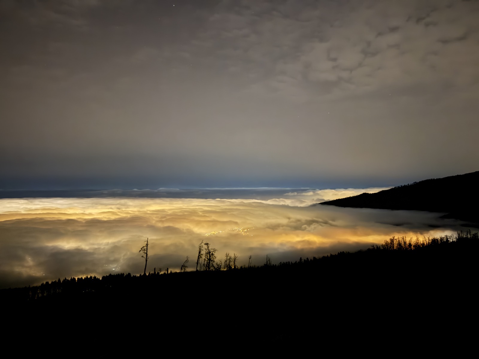
Sea Level to Teide Summit: The 0 to 3,715 m Challenge
Most people who climb Teide on foot start from a car park at 2,350 m and are rightly proud of themselves. There is a purer version of the idea: start with your heels in the Atlantic on a black-sand beach and climb every single metre of the highest mountain in Spain — 0 to 3,715 m in one unbroken line. On Tenerife it has a name, the Ruta 0-4-0, an official trail number, PR-TF 41, and a reputation as the island’s classic endurance challenge: sea level, roughly four vertical kilometres of cumulative climbing, and (for the truly committed) back down to zero again.
Honesty first. I have climbed the top third of this line — Montaña Blanca to the crater rim, overnight, in July 2026 — and know that section in the dark, at dawn and with jelly legs. The coastal and forest thirds I have not yet walked; what follows on those comes from the official trail documentation, a reference GPX of the classic route and first-hand accounts by people who have done the whole thing. I’ll be clear about which is which.
The route at a glance
The waymarked line — restored and signposted as PR-TF 41 around 2020 — starts at Playa del Socorro, a black-sand surf beach below Los Realejos on the north coast, and climbs the Tigaiga ridge on the western rim of the La Orotava valley: banana plantations, village streets, pine forest, the high-mountain desert of the caldera, and finally the summit cone via trail 7 (Montaña Blanca) and trail 10 (Telesforo Bravo).
The official listing calls it 27.7 km one way with about 4,000 m of accumulated ascent, difficulty “very high”. Our reference GPX of the classic itinerary — including the summit path and the inevitable wiggles — comes out slightly longer:
| Reference GPX (approx.) | |
|---|---|
| Distance, one way | ~30 km |
| Start / finish altitude | 0 m / 3,715 m |
| Cumulative ascent | ~4,500 m |
| Cumulative descent en route | ~800 m |
| Strong hikers, one way | ~11–16 h |
| Official estimate (hiking) | ~12 h |
| Trail runners | ~4–6 h |
That ~800 m of descent deserves a second look. There is no single big drop — the line rolls in dozens of small dips, after El Asomadero, through the forest belt and across the caldera floor — and every metre lost is a metre climbed twice. It’s why the cumulative ascent is closer to 4,500 m than the 3,715 m the altitude difference suggests.
This is also racing territory: the Tenerife Bluetrail by UTMB — the island’s flagship ultra, with a 110 km course and ~6,250 m of climbing that crosses the park at La Rambleta’s 3,555 m (the 2026 edition was cancelled at the last minute by storm Therese) — and its night vertical race, which storms up the same El Asomadero wall above Los Realejos that this route climbs more sedately. The races top out at La Rambleta rather than the crater, but the spirit is the same.
One confusion worth clearing up: Tenerife has two beaches called El Socorro. The classic route — and our reference GPX — starts from the one in Los Realejos, on the north coast. The other, near Güímar on the east coast, starts a different sea-to-summit variant that gains the Cumbre Dorsal at La Crucita (~2,050 m) and follows the ridge past the Izaña observatory to El Portillo. Fine route; wrong side of the island if you’ve downloaded the wrong GPX.
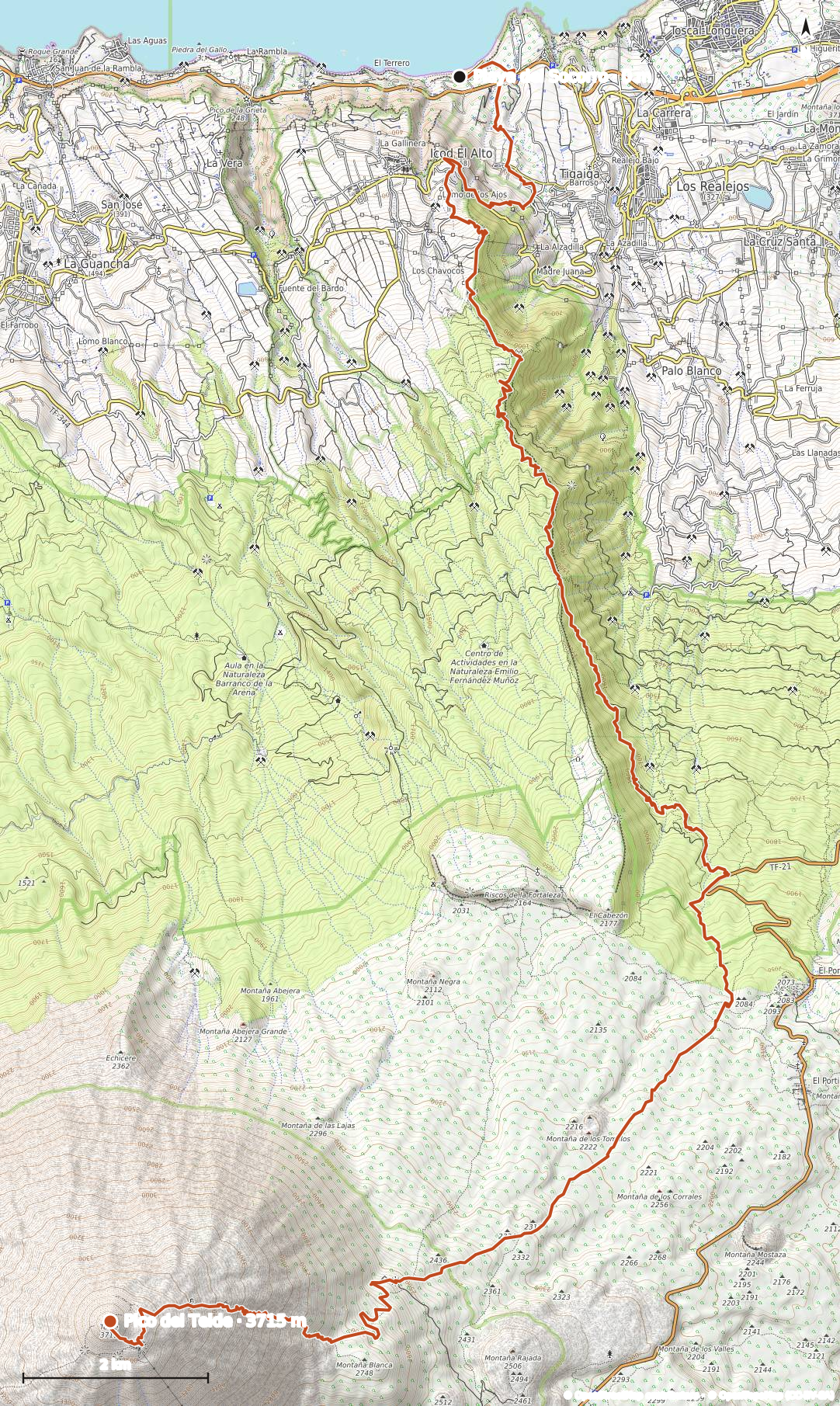 The full line from the Atlantic to the crater. This is a reference trace of the classic itinerary — not our own recording.
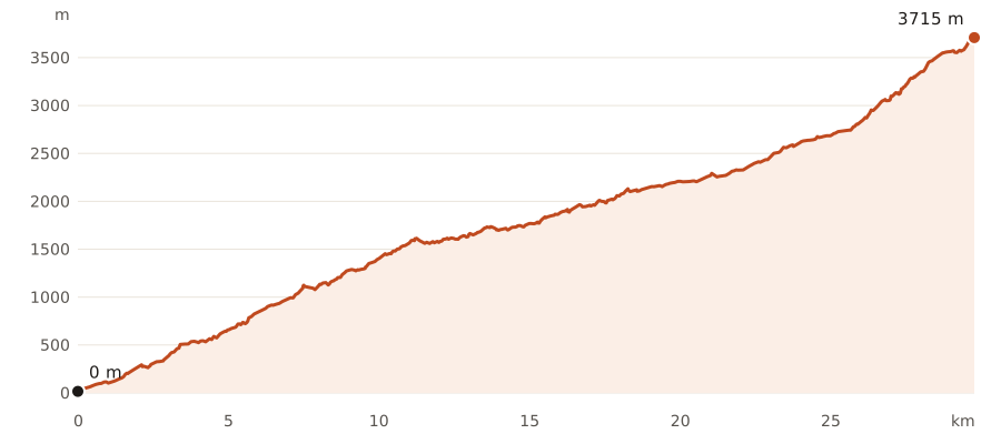 Roughly 30 km and ~4,500 m of cumulative climbing. Note the rolling middle third: the dips through the forest and across the caldera floor all have to be re-climbed.
The route, section by section
Playa del Socorro to La Corona: the brutal start (0–780 m)
The route wastes no time. From the beach it climbs steeply through banana plantations, passes under the TF-5 motorway and grinds up the steep streets of Tigaiga. Above the village it gains the Mirador de El Lance at about 540 m — with its monument to Bentor, last Guanche mencey of Taoro — then the Mirador de La Corona at roughly 780 m, a paragliding launch with the whole La Orotava valley at your feet. By all accounts this is the rudest gradient of the day, in the muggiest air. If you started pre-dawn, this is where that decision pays off.
The pine belt: La Corona to Degollada del Cedro (780–2,090 m)
Above La Corona the route enters the Corona Forestal and settles into a long, steady climb through Canary pines on the Tigaiga ridge: the Fuente de Pedro spring at around 1,000 m (reported as the last water on the route — more below), the El Asomadero viewpoint at ~1,100 m, the Piedra de los Pastores rest area at 1,600 m, with the Chanajiga recreation area linked by forest tracks on this flank of Los Realejos. The pines thin with altitude until, at the Degollada del Cedro (2,091 m, marked by a small chapel), you cross the caldera rim and the world changes: green behind you, volcanic desert ahead. This is the metronome section — a dozen rolling kilometres and 1,300 m of climbing where a sustainable pace is everything.
Across the caldera: the park boundary to Montaña Blanca (2,090–2,400 m)
Entering Teide National Park on the El Portillo side, the route crosses the Llano de las Brujas beneath the red ramparts of La Fortaleza, then follows park trails 22 (Lomo Hurtado) and 6 around the flank of Montaña Blanca to join trail 7 at roughly 2,400 m, about 22 km in. Accounts agree this stretch is deceptive: nearly flat on paper, it rolls constantly over coarse volcanic sand in full sun, with Teide visibly refusing to get any closer. Many finishers call it the psychological crux.
The summit cone: trail 7 and Telesforo Bravo (2,400–3,715 m)
From here I can speak first-hand, because this is the section I climbed in July 2026. Trail 7 passes the Huevos del Teide lava boulders, then rears into the infamous zigzags: tight switchbacks on loose pumice from about 2,750 m to the Refugio de Altavista at 3,260 m. Fresh, in the pre-dawn cool, this took me a couple of hard hours; with 25 km and well over 3,000 m of climbing already in your legs it will feel far longer. Above the refuge the path crosses blockier lava to La Rambleta (3,555 m) and the cable-car crowds, and the stepped path of Telesforo Bravo — trail 10, permit checked against your ID at the bottom — delivers you to the crater rim. Nothing is technical, but above 3,000 m every step is a small negotiation with the thin air, and the sulphur smell from the fumaroles tells you you’re nearly there. The full description of this section, with our recorded track, is in the hiking guide.
How hard is it, really?
Harder than the numbers look, and the numbers look hard. The standard Montaña Blanca ascent — itself a serious mountain day — is about 1,370 m of climbing; this is more than three times that, and it stacks the island’s two extremes into one outing: subtropical heat in the banana belt at the bottom, roughly 40% less oxygen at the top. You can be sweating at 25°C at 08:00 and shivering at 3,500 m the same afternoon — the summit sits below freezing with windchill in every month of the year.
The pattern in failed attempts is consistent: burn too many matches on the steep opening third, hit the caldera in midday heat already depleted, then meet altitude on the zigzags with nothing left. A fit hillwalker who paces the bottom conservatively can do this; a strong one takes 11–16 hours one way. Someone who has never done a 2,000 m day should not make this their first.
The permit problem
The final 160 m of Spain needs paperwork, and so does the upper part of trail 7. Booking works through the island’s Tenerife ON platform — not the old national parks site — and as of 2026:
- Trail 10 (Telesforo Bravo, the summit path) requires a booking; since 19 January 2026 non-residents pay €15 in the charged window (09:00–17:00). Outside those hours a reservation is still required but was free as of July 2026.
- Trail 7 (Montaña Blanca, upper section) needs its own separate reservation: €6 for non-residents on weekdays, €10 on weekends and holidays, charged 09:00–15:00.
- Slots release every Monday at 07:00 Canary time on a 56-day rolling window (doubled from 28 days in March 2026). Daily summit numbers are capped around 200, sunrise slots go first, and permits are nominal — carry the ID you booked with.
For a sea-to-summit day this is genuinely awkward: you commit, weeks ahead, to reaching trail 7 and then the summit path inside booked windows, after 25 km of variables. Build slack in — a late-afternoon trail 10 slot forgives more than a midday one — and have a bail plan, because wardens do turn people back at La Rambleta. If the Monday scramble fails, guided ascents carry their own permit allocation (compare options), though they climb from Montaña Blanca, not the sea. The full booking walkthrough is in the summit permit guide; and since Tenerife rewrote these rules several times between 2024 and 2026, check Tenerife ON before planning around any figure here.
One day or two?
The single push is the pure version: start at Playa del Socorro between about 02:00 and 04:00, cross the plantations and forest in the cool dark, hit the caldera by mid-morning, and take the zigzags in the early afternoon on your permit slot, finishing with daylight in hand for the descent. A midnight start for a sunrise summit is possible for the fast, but means doing almost the whole route in darkness.
The two-day version is what most people should do, and 2026 finally made it good again: the Refugio de Altavista at 3,260 m reopened on 20 July 2026 after five years shut and a full refurbishment. It has 49 bunks (plus four emergency beds), costs €71 a night for non-residents (€29 for Tenerife residents), is limited to one night, and — the killer feature — a stay includes access to the summit path between 06:00 and 09:00 the next morning, no separate trail 10 permit needed. Book ahead through the refuge’s own site, refugioaltavista.com, run by the cable-car operator — and note that the booking also covers trail 7 for the walk up (check-in window 15:00–midnight), so refuge guests need no separate Tenerife ON reservations at all. Day one becomes a huge but manageable ~27 km to the refuge; day two is a headtorch stroll to the crater for sunrise.
A third pattern splits lower: walk to El Portillo (~17 km, ~2,100 m) or the Montaña Blanca car park on day one, get picked up, sleep low, and return for the summit day. Less elegant — the line is broken — but it removes the altitude-on-empty-legs problem entirely.
Water: the route is drier than it looks
Treat this route as waterless after the forest begins. The Fuente de Pedro spring at ~1,000 m is reported in walkers’ accounts as the last refill point, but a spring in someone else’s trip report is not a plan — carry as if it doesn’t exist. There is nothing in the caldera, nothing on trail 7, and the first reliable purchase is vending machines at the Altavista refuge and the upper cable-car station, both above 3,200 m and both dependent on being open and stocked.
That means starting with 4–5 litres per person on a warm day, or doing what locals do: cache water the day before at a road or track crossing — El Portillo is the obvious point. I drank 3.5 litres on the top third alone in July; scale accordingly. Dehydration also amplifies altitude sickness — arriving at 3,000 m already dry is how a headache becomes a retreat.
Escape points: where you can bail
One of this route’s virtues is that it never strays far from rescue-yourself options:
| Point | ~Km | Altitude | Exit |
|---|---|---|---|
| Mirador de La Corona | ~6 | ~780 m | Road at Icod el Alto; short walk to villages |
| Chanajiga area | ~10 | ~1,300 m | Forest tracks to Palo Blanco (Los Realejos) |
| El Portillo visitor centre | ~18 | ~2,050 m | Short detour east; TF-21/TF-24 junction, café, bus, taxi pick-up |
| Montaña Blanca car park | ~24 | 2,350 m | TF-21 lay-by — easiest pick-up point |
| La Rambleta | ~29 | 3,555 m | Cable car down (if running) |
El Portillo is the strategic one: just past halfway, with a road junction and visitor centre, it’s the last sensible place to decide whether the top third is happening today. Note that scheduled mouflon-control days close park and forest-crown trails on this corridor in spring (April–May) and autumn (October–November), on set weekdays from 07:00 until mid- to late afternoon — check the closure calendar on Tenerife ON before setting a date in those months.
Getting to the start — and down from the top
To Playa del Socorro: the beach sits below Los Realejos, about 15 minutes’ drive west of Puerto de la Cruz. Titsa buses serve the El Socorro area — line 363 along the north coast is the usual answer, check current timetables — but for a 03:00 start you’ll want a pre-booked taxi from Puerto de la Cruz: short money against the day you’re about to have. Logistics for the park end of the island are in getting to Teide.
Down from the summit you have exactly two options. The dignified one: a descent-only cable-car ticket from La Rambleta — €23.50 for a non-resident adult in 2026, sold on the spot by QR code at the top station, not pre-bookable, and only when the cable car is running. Mind the cut-offs: last descent 18:30 on the summer timetable (July–September), 16:50 most of the year, and it shuts in strong wind at short notice. The stubborn one: walk down trail 7 to the Montaña Blanca car park (3–4 knee-punishing hours) and get collected there. Either way, budget the legs and daylight to walk down — a cable car is a convenience, never a plan.
Planning this route? Download the reference GPX of the classic itinerary — teide-sea-to-summit.gpx — and load it into your navigation app. To be clear: it’s a reference line of the classic route, not our own recording. Our recorded Montaña Blanca→summit track from July 2026 lives in the hiking guide.
When to attempt it
The route’s two climates argue with each other. Summer means snow-free upper trails but genuinely dangerous heat in the bottom 1,500 m — July and August attempts live or die on a pre-dawn start. Winter flips it: pleasant plantations, but snow and ice regularly close trails 7 and 10 between roughly December and March, and an iced zigzag section ends the day at Altavista.
The sweet spots are late spring (April–June) and autumn (October–November): tolerable heat low down, usually clear trails up high, enough daylight. Whatever the season, the north-coast start sits under the trade-wind cloud belt — expect humidity and possible drizzle in the forest even when the caldera is bone dry — and treat calima (Saharan dust) forecasts as a postponement. Season-by-season detail is in the best time to visit.
Training and kit
Train with back-to-back big days — a 1,500 m day is honest preparation; two consecutive ones are better — and if you can’t train at altitude, at least learn how your body behaves above 3,000 m before betting a 30 km day on it. A cable-car trip to La Rambleta on a rest day will tell you a lot.
Kit is the standard Teide summit list — headtorch plus spares, windproof shell, insulated jacket, hat and gloves even in July, factor 50, boots or sturdy trail shoes, poles — with three route-specific additions: far more water than feels reasonable (or a caching plan), sun protection for the exposed midday caldera crossing, and clothing for the muggy, possibly drizzly forest belt that you’d never pack for the summit alone. Full seasonal kit lists are in the hiking guide.
Frequently asked questions
Can you really hike from sea level to the top of Teide in one day?
Yes — the waymarked PR-TF 41 (Ruta 0.4.0) runs from Playa del Socorro in Los Realejos to the summit in one continuous line, and fit hikers complete it in a single push of roughly 11–16 hours. It requires two advance reservations (trail 7 and the trail 10 summit path, both on Tenerife ON), a pre-dawn start to beat the heat, and honest fitness for ~30 km with ~4,500 m of ascent. Trail runners do it in 4–6 hours; most walkers should split it over two days.
What does “Ruta 0-4-0” mean?
It’s the local nickname for the challenge: start at 0 m, climb roughly 4,000 vertical metres (the summit is 3,715 m, but the rolling route adds several hundred metres of re-climbing), and — in the full version — descend back to 0, a round trip of some 56 km. The waymarked trail is officially PR-TF 41; the same idea powers the island’s ultra races, including the Tenerife Bluetrail by UTMB.
Do you need a permit for the sea-to-summit route?
Two, under the 2026 rules. The upper section of trail 7 needs a reservation — €6 weekdays / €10 weekends for non-residents in the 09:00–15:00 window — and the Telesforo Bravo summit path needs a separate Tenerife ON booking with a €15 eco-fee for non-residents between 09:00 and 17:00. Slots release Mondays at 07:00 Canary time on a 56-day window. Everything below the park needs nothing. An overnight at the Refugio de Altavista includes both trails — trail 7 for the ascent and summit access from 06:00 to 09:00 the next morning — replacing the separate permits for refuge guests.
Where can you sleep on the route?
At the Refugio de Altavista (3,260 m), reopened on 20 July 2026: 49 bunks, €71 a night for non-residents (€29 for Tenerife residents), one night maximum, booked in advance. It sits at the perfect point — about 27 km in, with only 450 vertical metres left for a sunrise summit. There is no other accommodation on the line; the alternative is bailing to a road at El Portillo or Montaña Blanca and sleeping low.
Is there any water on the route?
Effectively none. Walkers’ accounts mention the Fuente de Pedro spring at about 1,000 m as the last source, but don’t stake the day on it. Above the forest there is nothing until the vending machines at the Altavista refuge and the top cable-car station. Carry 4–5 litres per person in warm weather, or cache bottles at El Portillo the day before — an established local tactic on this route.
How much harder is it than the normal Teide hike?
Roughly three times the climbing — ~4,500 m cumulative against ~1,370 m from the Montaña Blanca car park — plus 20 extra kilometres and the coastal heat the standard route never touches. Crucially, you arrive at the altitude crux (the zigzags above 2,750 m) with a marathon-scale effort already in your legs. If the standard route took everything you had, do this one over two days with a refuge night, or not yet.