Geology
Las Cañadas Caldera: The 16 km Bowl Teide Sits In
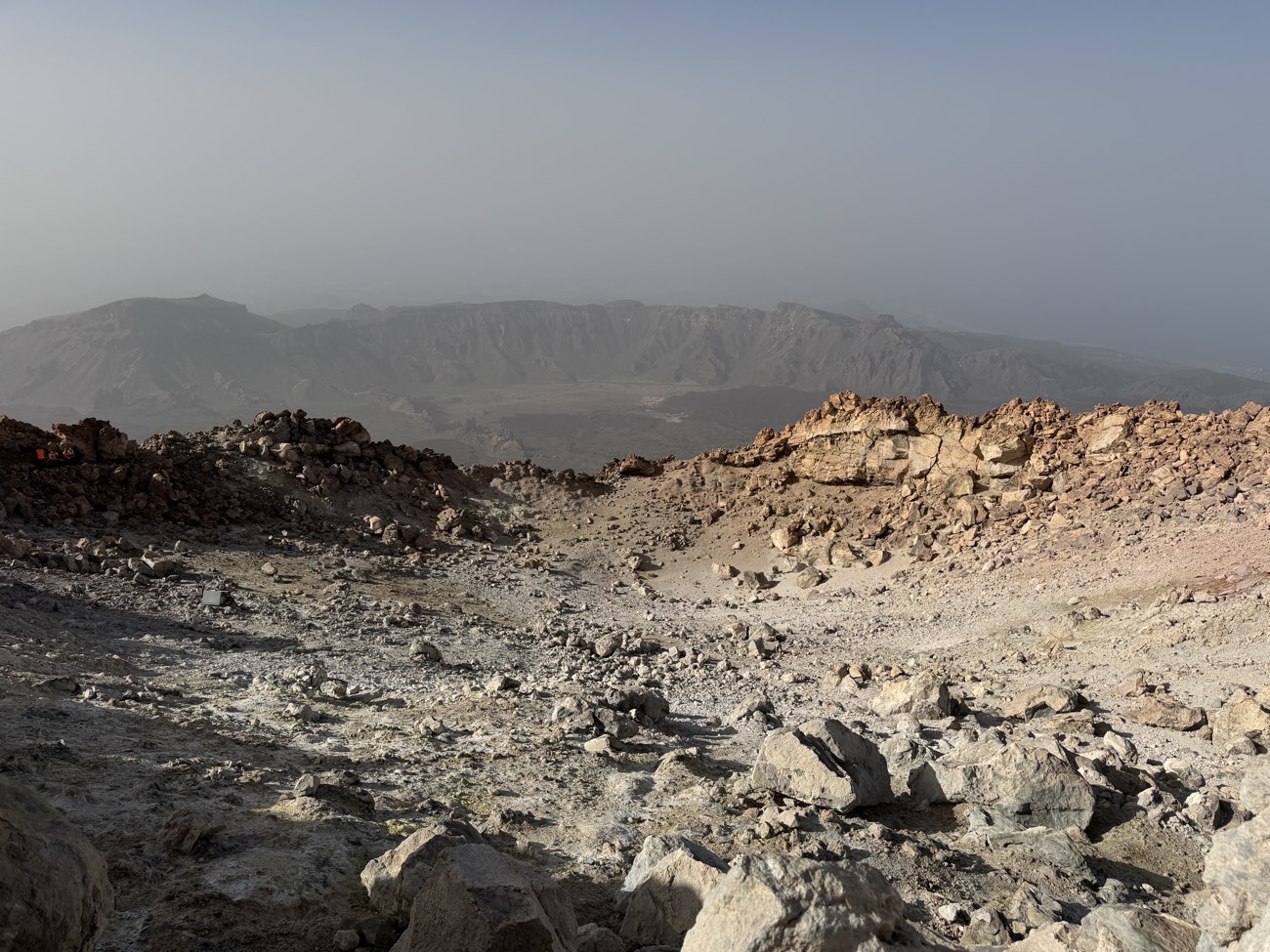
The road climbs through the pine belt, the trees thinning as the gradient steepens, and then the land drops away and you are inside it. The depression that holds Mount Teide is roughly 16 kilometres across one way and 10 the other, an oval bowl whose southern and eastern walls rise in a continuous escarpment of layered rock, while the northern side is simply gone. This is Las Cañadas caldera, and the mountain at its centre did not build the bowl — it was built inside it, on a floor that was once much deeper than it is now.
The name cañadas does not refer to canyons or channels, as a Spanish speaker might guess. It means the flat, sediment-filled plains at the foot of the wall, of which Llano de Ucanca is the largest. After heavy rain, water pools across that plain and reflects the rock wall in a perfect horizontal line, and for a few hours the caldera looks as if it has been flooded and then drained again. The rest of the year, the floor is dry, pale, and scattered with volcanic rubble.
The wall and the gap
The caldera rim reaches its highest point at Guajara, 2,700 m, a peak on the southern wall that gives the best view of the whole depression. From Guajara, the wall runs east and west as a near-continuous cliff, broken only by the road pass at El Portillo, the park’s northern gateway. The southern and eastern arc is dramatic enough that visitors often assume the whole caldera is a ring. It is not. The northern side is open, and the ground slopes away toward the coast in a long, eroded ramp. That missing northern wall is the central problem in the debate about how the caldera formed.
Stand on the rim at Guajara and look north. The mountain rises from the caldera floor, but beyond it the rim does not close. The landscape falls away into the Icod valley, a broad amphitheatre that runs down to the sea. Something removed a huge volume of rock from that side of the island. The question is what.
Two explanations, one caldera
Geologists have argued about Las Cañadas for decades, and the literature still carries both accounts. The article presents them as competing explanations because they genuinely are, though current thinking generally favours a combination of the two.
Vertical collapse. In this model, a large magma chamber beneath the old volcano emptied during a series of explosive eruptions, and the roof of the chamber collapsed inward, forming a bowl. This is how many large calderas on Earth form — Santorini, Krakatoa, Yellowstone. The intact southern and eastern wall looks like a classic collapse scarp. The problem is the missing northern wall. If the collapse was purely vertical, the rim should be roughly circular. It is not.
Lateral landslide. In this model, a giant landslide removed the island’s north flank, taking the northern wall with it and leaving the horseshoe shape we see today. The Icod landslide, dated to around 180,000 years ago, is the event usually cited. It removed enough rock to form the Icod valley and, proponents argue, created the open northern side of the caldera. The landslide debris has been found offshore in seismic surveys, a thick deposit on the seafloor north of Tenerife.
The current consensus is that both processes acted. A series of vertical collapses may have weakened the structure, and a lateral landslide then removed the northern flank. Or a landslide may have triggered decompression that led to collapse. The details are still being worked out, and the literature uses careful language — “multi-stage”, “complex”, “not fully resolved”. The honest answer is that the caldera is a hybrid, and the precise sequence is not settled.
| Process | What it involves | Evidence for it |
|---|---|---|
| Vertical collapse | Magma chamber empties, roof falls in | Intact southern and eastern scarp; classic caldera morphology |
| Lateral landslide | North flank slides into the sea | Open northern side; offshore debris field; Icod valley |
What the floor holds
After the caldera formed, volcanic activity continued inside it. The Teide–Pico Viejo complex built up on the caldera floor, not on the original island surface. The floor itself had been deepened by collapse and then partly refilled by later eruptions. The result is that Teide stands on a broad, flat base rather than rising directly from a mountain slope.
The caldera floor is not uniform. The Llano de Ucanca is the largest of the flat sediment plains, but there are others, separated by ridges and rock formations that were left standing when the rest of the floor dropped. The most prominent of these is the Roques de García, a wall of rock that divides Ucanca from the eastern part of the caldera. Roque Cinchado, the slender pillar known as the Árbol de Piedra or stone tree, is part of this formation. It appeared on the old 1,000-peseta banknote and is probably the most photographed rock on the island.
The Roques de García stand on the caldera floor, not on the rim. They are remnants of the original volcanic edifice that survived the collapse, like teeth left in a jaw after the rest has gone. The rock is layered, tilted, and cut by dykes, and it gives a sense of the internal structure of the volcano that was lost when the caldera formed.
The road and the rim
The TF-21 crosses the caldera floor, climbing from El Portillo in the north and running south past the Roques de García and the Parador before climbing the flank of the mountain to the cable-car base station. From the road, the caldera wall is a constant presence on the left, a wall of layered basalt and trachyte that catches the afternoon light. The road does not climb the rim — it crosses the floor and then leaves the caldera through the open northern side.
El Portillo, at the northern entrance, is the park’s main visitor centre and the point where most people first see the caldera. Coming from the north, the road drops through a narrow pass and the depression opens suddenly. The view is of the flat floor, the Roques de García, and the mountain rising beyond them. The caldera wall to the south is visible as a distant line.## What the caldera tells us
The caldera is not a crater. A crater is a vent feature, formed by eruption or impact. A caldera is a collapse feature, formed when the ground falls into a space that was once filled with magma. The distinction matters because it changes what the landscape means. The bowl that holds Teide is evidence of a volcano that was once much larger and that destroyed itself in the process of emptying its own plumbing.
The debate about how it happened is not an academic indulgence. The mechanism of caldera formation affects how geologists assess the hazard of the current volcano. A system that has collapsed vertically is different from one that has slid laterally. The combination of both, as seems to be the case here, makes the risk assessment more complex. The monitoring networks run by INVOLCAN and IGN — seismometers, GPS stations, gas sensors — are designed in part to detect the kind of deformation that might precede another collapse, however unlikely in the short term.
The caldera is also a fossil of the island’s volcanic adolescence. Tenerife is not old, geologically. The island emerged from the sea less than 12 million years ago, and the Las Cañadas volcano that preceded the caldera was active for perhaps three and a half million years before it collapsed. The caldera marks the end of that phase and the beginning of the current one, in which the Teide–Pico Viejo complex has built a new volcano inside the ruins of the old one.
Stand on the rim at Guajara and the sequence is legible in the rock. The wall shows the layers of the old volcano, tilted and truncated. The floor shows the younger flows that have partly filled the depression. The mountain shows the current phase, still active, still monitored, still growing. The caldera is the middle term in that geological sentence, and it is the reason the mountain looks the way it does.