Reference
Mount Teide: The Highest Mountain in Spain
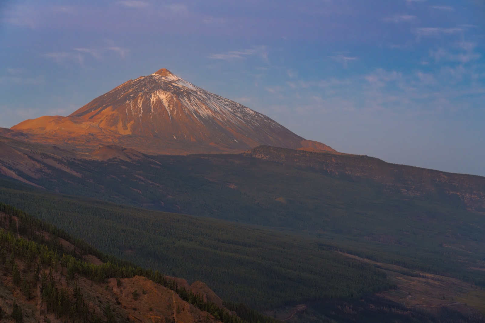
At 3,715 m (12,188 ft), Mount Teide is the highest point in Spain. That single figure belongs not to the Pyrenees or to the Sierra Nevada of the mainland, but to Tenerife, in the Canary Islands. It is higher than any peak in peninsular Spain by a margin of roughly 236 m. Behind that ranking sits a deeper measure: Teide is the exposed summit of a volcanic structure that rises roughly 7,500 m from the ocean floor.
The highest point in Spain
Spain’s highest summit is an island volcano. That is the central fact of Spanish mountain geography, and it quietly overturns a common assumption about the country’s peaks. The Pyrenees, long the best-known mountain frontier in Spain, do not contain the national high point. That distinction belongs to the Sierra Nevada in the south, whose highest summit, Mulhacén, reaches 3,479 m.
The ranking is therefore not especially close at the top. Teide exceeds Mulhacén by about 236 m, an interval large enough that no reasonable measurement dispute disturbs the order. The real interest is not first against second, but where the other leading summits fall, and why an island should head the list at all.
The three peaks that lead the table
The top of the Spanish ranking is compact and clear.
| Peak | Range | Elevation |
|---|---|---|
| Teide | Tenerife, Canary Islands | 3,715 m |
| Mulhacén | Sierra Nevada | 3,479 m |
| Aneto | Pyrenees | 3,404 m |
Mulhacén is the highest point on the Spanish mainland. Veleta, in the same range, is also among Spain’s highest summits, though slightly lower than Aneto on most published figures. Aneto, at 3,404 m, is the highest point in the Pyrenees.
The table should not be extended casually. Elevations below the top three or four often vary between sources by a few metres, and the differences matter more for climbers than for any broad geographical claim. The three names above, however, are firmly established in their positions.
Mulhacén and the Sierra Nevada reversal
It is worth stating the pattern plainly: several of Spain’s highest summits are in the Sierra Nevada, not the Pyrenees. That reverses the expectation carried by many readers who associate Spanish high mountains with the northern frontier. The Pyrenees form a formidable chain, but their highest point, Aneto, is lower than Mulhacén.
The Sierra Nevada’s altitude comes from a different geological setting. The range lies in the south of the peninsula and rises abruptly from the surrounding lowlands to a compact high core. Its two best-known summits, Mulhacén and Veleta, sit close to one another and dominate the skyline above Granada. That concentration of high ground is unusual in Spain, and it explains why the mainland record sits there rather than in the more famous chain to the north.
Why an island tops the table
Tenerife is a volcanic ocean island built upward from the seafloor, and that is the reason its summit stands above the mainland. A mountain range on the peninsula begins from whatever elevation its surrounding terrain provides. An oceanic volcano begins far below the sea surface and accumulates layer upon layer until a single point emerges above the Atlantic.
Teide’s summit elevation of 3,715 m is measured from sea level, the standard reference for national height records. That is what places it first in Spain. But the volcano does not start at sea level. Its base lies on the ocean floor, and the full structure rises roughly 7,500 m from that base to the summit. That figure reframes the mountain: the Spanish high point is not merely tall among Spanish peaks, but the top of one of the largest volcanic constructions on Earth, depending on how it is measured.
Measured from the seafloor, not sea level
The distinction between summit elevation and total height explains most of the confusion around Teide’s claims to size. When a mountain is ranked by elevation above sea level, Teide is 3,715 m and is the highest point in Spain. When the same structure is measured from its submarine base, the figure becomes something like 7,500 m.
Both numbers are real. They answer different questions. The first answers a simple national question: where is the highest land in Spain. The second answers a geological question: how large is the volcanic edifice beneath that highest point. A similar logic applies to other ocean-island volcanoes. Their above-water summits can look modest by continental standards, while their total relief is far larger than the visible portion suggests.
A volcano that is still active
Teide is not merely a geological relic. The mountain is active but not currently erupting, a status usually described as dormant rather than extinct. Its most recent eruptive activity occurred in 1798, when the Narices del Teide eruption opened on the flank of Pico Viejo and lasted for around three months. That event did not involve the summit crater itself, but it was part of the same volcanic system.
Tenerife’s most recent eruption anywhere on the island came in 1909 at Chinyero. Since then, the mountain has been quiet at the surface, but it is watched closely. Monitoring is run by INVOLCAN and IGN, using seismometers, GPS and gas measurement to track changes in the system. In 2004, an anomalous seismic swarm, the so-called 2004 seismic crisis, reminded the island that the volcano is still very much alive. No monitoring agency can predict an eruption date, and no reputable source attempts one. The point is simply that Spain’s highest mountain is a living volcano, not a finished monument.
The caldera that cradles the peak
Teide does not rise from a flat plain. It sits inside Las Cañadas, a vast caldera roughly 16 km by 10 km, whose rim reaches about 2,700 m at Guajara. The caldera floor, a high-altitude plain of pumice and lava, forms one of the most striking volcanic landscapes in the world. The Roques de García, a wall of rock separating the Llano de Ucanca from the rest of the caldera, includes Roque Cinchado, the “stone tree” that once appeared on the 1,000-peseta banknote. To the north, the caldera rim is marked by La Fortaleza, a steep escarpment. The pale pumice fields of Minas de San José, used as a planetary analogue, lie nearby. Below the summit, the Cueva del Hielo lava tube holds ice year-round, a reminder of the mountain’s internal cold.
The caldera itself is the scar of an ancient landslide and subsequent volcanic collapse, a reminder that the mountain we see is only the latest chapter in a long and violent geological story. The oldest subaerial rocks on Tenerife date back roughly 12 million years, and the island’s north flank was removed by a giant landslide around 180,000 years ago, forming the Icod valley. Teide and its neighbour Pico Viejo (3,135 m) are the young cones that have grown inside that older amphitheatre.
A national park and a world heritage site
Teide National Park was created in 1954, and in 2007 UNESCO inscribed it as a World Heritage site. The designation recognises both the volcanic landscape and the extraordinary clarity of the sky above it. The park contains the Parador de Las Cañadas del Teide at around 2,150 m, and the Altavista refuge at 3,260 m, which reopened in July 2026 after refurbishment.
Entry to the national park is free, though the cable car is a separate paid service. The cable car base station sits at 2,356 m on the TF-21 road, and the upper station, La Rambleta, reaches 3,555 m in about eight minutes. From there, the final ascent to the summit requires a permit for the Telesforo Bravo trail, with roughly 300 places available per day. The practical details of booking and timing belong to a separate guide, but the existence of that permit system underlines the mountain’s protected status.
The highest plants in Spain
Teide’s summit cone is home to the Teide violet (Viola cheiranthifolia), Spain’s highest-growing flowering plant. It is a small, tough endemic that survives among the scree and pumice at altitudes where few other plants can manage. Lower down, the slopes are covered in spring by the towering flower spikes of the tajinaste rojo (Echium wildpretii), also called tower of jewels. This plant is monocarpic: it flowers once, spectacularly, then dies. Its spikes can reach 3 m in height and turn whole hillsides red in late spring and early summer. The dominant shrub of the high zone is the retama del Teide (Spartocytisus supranubius), whose white blooms give the landscape a pale, almost lunar quality.
The pine belt below the national park is the realm of the Canary Island pine (Pinus canariensis), a tree that resprouts after fire and combs moisture from the passing cloud. Among its branches lives the Tenerife blue chaffinch (Fringilla teydea), a bird found nowhere else. On the open ground, the Tenerife lizard (Gallotia galloti) scurries between rocks, the males showing blue throat and flank markings. Berthelot’s pipit (Anthus berthelotii) is a common sight on the high trails. Introduced mouflon, brought to the island in 1971 for hunting, have since become a threat to the endemic flora and are subject to control programmes.
The observatory and the protected sky
At around 2,390 m on the ridge of Izaña sits the Teide Observatory, run by the Instituto de Astrofísica de Canarias. The site benefits from an atmosphere that is unusually stable and free of light pollution, a quality protected since 1988 by Spain’s “Sky Law” (Ley 31/1988). The observatory is one of the world’s premier astronomical sites, and the clarity of the night sky above the caldera has made the national park a destination for stargazing.
The mountain’s astronomical history goes back further. In 1856, the Scottish astronomer Charles Piazzi Smyth conducted a high-altitude expedition on Teide, one of the earliest attempts to place a telescope above the densest part of the atmosphere. His work helped establish the principle that mountain observatories could see more clearly than those at sea level.
Humboldt and the early visitors
Alexander von Humboldt visited Tenerife and climbed Teide in June 1799, during the voyage that would make him one of the most celebrated naturalists of his age. His account of the ascent, with its careful observations of vegetation zones and atmospheric conditions, helped fix the mountain in the European imagination. Humboldt was not the first to climb Teide, but his description gave it a scientific and literary currency that it has never lost.
The Guanches, the island’s pre-conquest inhabitants of North African origin, had known the mountain for centuries before any European set foot on it. They called it Echeyde, and their sacred geography treated the high ground with ritual restriction. The mountain was not merely a landmark but a dwelling place of powerful forces.
Echeyde: the name under the summit
The name Teide is usually derived from Echeyde, the Guanche name for the mountain. In the account that has survived, a malign spirit named Guayota lived inside the peak. Guayota captured Magec, the sun deity, and plunged the world into darkness. The supreme sky god Achamán defeated Guayota and sealed him inside the mountain, leaving the pale summit plug as the seal. The story explains both the mountain’s appearance and its sacred status.
This remains the leading derivation of the name. It is not the only one, and the etymology is better presented as probable than as settled. What is secure is that the mountain carried enormous meaning for the people who lived beneath it long before Spanish surveyors gave it a numeral.
Reaching the three highest points
The three leading summits differ sharply in access. Teide’s summit is reached by a combination of cable car and a final permitted trail: the cable car rises to 3,555 m, leaving a short but regulated climb above that station. Alternatively, the classic walking ascent begins at Montaña Blanca (c. 2,750 m), a pumice cone roughly 2,000 years old. Trail 7 climbs past the Los Huevos del Teide — strange accretionary lava balls — to the Altavista refuge at 3,260 m, which reopened in July 2026. From there, the route continues to La Rambleta and the summit, still requiring the same Telesforo Bravo permit.
Mulhacén and Aneto are approached quite differently. Mulhacén is a high mountain walk, long but non-technical in summer. Aneto is a genuine mountaineering ascent involving glacier or snowfield travel, depending on conditions, and it demands more alpine competence than either of the other two.
For Teide the practical questions of permits and timing sit in their own guide. The Teide hiking guide covers the trail detail without reopening the whole subject here.
The Europe question remains one of definition
Teide is the highest point in Spain. Whether it is also the highest point in Europe is a different question, and it depends on how Europe is defined. The Canary Islands are politically part of Spain and therefore part of the European Union, but their geographical position has led to disagreement over whether they belong to the European landmass for the purposes of mountain ranking.
Some classifications include the archipelago and therefore place Teide first in a European list. Others exclude it, which changes the result entirely. The disagreement is not about the 3,715 m measurement. It is about the boundary of a continent, a boundary that does not exist in nature as a single agreed line. For that reason, the sensible statement is narrow: Teide is the highest point in Spain, and the highest point in the Atlantic islands. Any wider claim must state its definition first.
The older figure that refuses to disappear
Anyone looking at older maps or signs around the mountain will see 3,718 m, not 3,715 m. The smaller figure is the modern surveyed elevation. The larger one lingers because it was the accepted published height for much of the twentieth century, and it remains printed on material that has not been corrected.
The difference of 3 m is trivial for all practical purposes. It does not alter the national ranking. It does, however, illustrate how mountain elevations are revised as surveying methods improve. The mountain has not changed height. The measurement has become more precise. The old number survives as a minor artefact of cartographic history, one that occasionally confuses visitors who notice the two figures side by side.